Site 47 - Long Pond - PEM
Long Pond - PEM |
|
Site
Identification
|
| CWC Reference Number: | 47 |
| State: | PA |
| County: | Monroe |
| Municipality: | Tunkhanock |
| USGS Quad: | Pocono Pines |
| Watershed: | Tunkhanock Creek |
| Hydrogeomorphic Class: | Headwater Floodpln |
| Disturbance Class: | Pristine |
| Dominant Vegetation Class: | PEM |
| Wetland Area: | 0.04 ha (0.1 ac) |
| Year(s) Sampled: | 1995 |
Site 47 - Long Pond - PEM
|
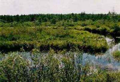
Vegetation
|
| Herbaceous |
| Percent cover: | 77.5% (range 25-100%) |
| Dominant Species |
| Common Name: | Scientific Name: |
| Shallow sedge | Carex lurida |
| Skunk cabbage | Symplocarpus foetidus |
| Upright sedge | Carex stricta |
| Royal fern | Osmunda regalis |
| Sphagnum |
---
|
| Woody |
| Percent cover: | 55.8% (range 5-100%) |
| Dominant Species |
| Common Name: | Scientific Name: |
| Red maple | Acer rubrum |
| Northern arrowwood | Viburnum recognitum |
| Swamp azalea | Rhododendron viscosum |
| Alder | Alnus sp. |
| Highbush blueberry | Vaccinium corymbosum |
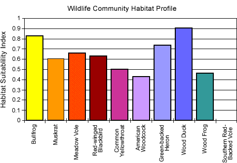
| Weighted Indicator Status (dominant spp.) |
| Herbaceous: | 1.01 |
| Woody: | 2.07 |
| Indicator Status (all spp.) |
| Herbaceous: | 1.00 |
| Woody: | 2.61 |
| Species Richness |
| Total: | 23 |
| Herbaceous: | 16 |
| Woody: | 7 |
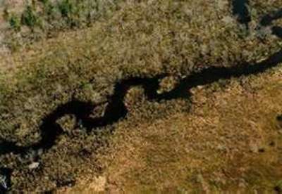
Aerial View of Long Pond - PEM
|
Soils
|
| Matrix Chroma (mean): | 2.0 |
| Organic Matter (mean %): | 58.72 |
| Bulk Density (g/cm2): | 0.12 |
| Soil Series: | NA |
| Texture (mean %) |
|
Sand:
|
34.9 |
|
Silt:
|
32.4 |
|
Clay:
|
32.7 |
| Sedimentation Rate |
| Mineral loading (g/cm2): | NA |
| Equivalent depth (cm): | NA |
| Organic loading (g/cm2): | NA |
|
Hydrology
|
| Water Level |
| Median (cm): | NA |
| Range (cm): | NA |
| Water Quality |
| pH (mean): | NA |
| Conductivity (mean): | NA |