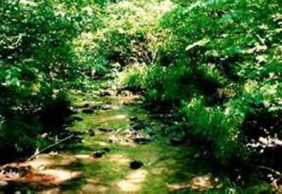
Site 33 - Lee's Gap
Lee's Gap |
|
Site
Identification
|
| CWC Reference Number: | 33 |
| State: | PA |
| County: | Centre |
| Municipality: | Walker |
| USGS Quad: | Madisonburg |
| Watershed: | Little Fishing Creek |
| Hydrogeomorphic Class: | Slope |
| Disturbance Class: | Severe |
| Dominant Vegetation Class: | *PSS/PFO |
| Wetland Area: | 0.2 ha (0.5 ac) |
| Year(s) Sampled: | 1994 |
Site 33 - Lee's Gap
|
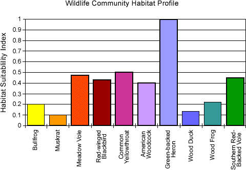
Vegetation
|
| Herbaceous |
| Percent cover: | 74.5% (range 40 -100%) |
| Dominant Species |
| Common Name: | Scientific Name: |
| Grass |
---
|
| Sedge | Carex sp. |
| Sedge | Carex retroflexa |
| Ground ivy | Glecoma hederacea |
| Canada golden rod | Solidago canadensis |
| Woody |
| Percent cover: | 46.8% (range 0-95%) |
| Dominant Species |
| Common Name: | Scientific Name: |
| Northern spicebush | Lindera benzoin |
| Speckled alder | Alnus incana |
| Multiflora rose | Rosa multiflora |
| Hawthorn | Crataegus sp. |
| Mountain ash | Pyrus malus |
| Weighted Indicator Status (dominant spp.) |
| Herbaceous: | 2.51 |
| Woody: | 3.17 |
| Indicator Status (all spp.) |
| Herbaceous: | 3.00 |
| Woody: | 2.33 |
| Species Richness |
| Total: | 79 |
| Herbaceous: | 72 |
| Woody: | 7 |
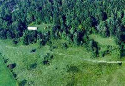
Aerial View of Lee's Gap
|
Soils
|
| Matrix Chroma (mean): | 1.0 |
| Organic Matter (mean %): | 11.76 |
| Bulk Density (g/cm2): | 0.64 |
| Soil Series: | Andover very stony loam |
| Texture (mean %) |
|
Sand:
|
31.9 |
|
Silt:
|
54.4 |
|
Clay:
|
13.8 |
| Sedimentation Rate |
| Mineral loading (g/cm2): | 2.18 |
| Equivalent depth (cm): | 1.7 |
| Organic loading (g/cm2): | 0.41 |
|
Hydrology
|
| Water Level |
| Median (cm): | -50.0 |
| Range (cm): | -52.0 - (-27.0) |
| Water Quality |
| pH (mean): | 7.0 |
| Conductivity (mean): | 350.3 |