
project categories
- wetlands and watersheds
- ecological restoration and creation
- ecological indicators and wildlife
- public outreach
- reference wetlands
related items

research project details
| Project Title: | Classifying and Prioritizing Watersheds for Protection and Restoration:
An Approach for the Mid-Atlantic Highlands Area
(Final report available in left sidebar) |
| Investigator(s): | Robert P. Brooks, G.P. Patil, and George D. Constantz |
| Sponsor: | U.S. Environmental Protection Agency |
Research Project Objectives:
Develop a standardized process for classifying and prioritizing watersheds by:
- Developing a geographically-independent classification system that links watershed characterization and prioritization;
- Compiling synoptic data for a set of relevant anthropogenic stressors for the region;
- Using existing ecological data to validate our watershed classification system; and
- Comparing the rankings from our models to those of other classification approaches.
Summary of Findings:
Natural resource managers need to be able to put watersheds into categories for several reasons, including identifying reference conditions, understanding types of environmental degradation, designing monitoring studies, and narrowing restoration options. In this project, we explored ways to develop and apply a hierarchical, geographically-independent classification of watersheds based on pre-existing environmental data.
Our work was focused on the Mid-Atlantic Highlands Area, but has applications elsewhere. Our approach in this project was to first construct a classification system that characterizes watersheds based on their inherent natural features (climate, soils, topography and hydrology). This resulted in the delineation of nine distinct clusters of watersheds for the region. We then developed an approach to prioritization that classifies watersheds according to human disturbance (primarily expressed through land cover) and their susceptibility to impairment from a variety of stressors, including land use, acidification, impervious cover, and nutrients.
Based on our research products and conversations with potential users, we discovered that the best way to “prioritize” watersheds was to use an interactive process. We produced maps of our nine cluster groups showing their spatial distribution in the region. These maps can be used by managers to recognize where and how their specific watersheds of concern fit into a larger landscape context. We produced narrative descriptions of the nine watershed clusters that relate their inherent characteristics to their vulnerability of being impacted by a suite of stressors. This approach is preferred to one where researchers impose a prioritization scheme on potential users. This method also allows users to incorporate other information and data that address the invariably unique issues at hand for that single watershed or group of watersheds. Given that we delineated over 2,800 small watersheds in the study area, this seemed to be the most appropriate approach.
We tested the efficacy of our classification system across watersheds in the state of West Virginia, where the best synoptic measure of ecological integrity was available. Using measures of land use in the watershed and riparian corridor, and stream biological integrity, we found that that the nine clusters of watersheds were sufficiently differentiated that they showed variations in vulnerability to human-generated stressors. Vulnerability (ecological resistance) tended to have an inverse relationship with likelihood of land use impacts: high vulnerability watershed classes tended to have relatively low land use impacts, while low vulnerability watershed classes tended to have relatively high land use impacts.
Our recommendations to potential users are to locate watersheds of interest, determine their cluster membership, and then consider their vulnerability to expected stressors. By understanding the inherent characteristics that define each cluster, and considering the watershed’s probable response to specific stressors, one can conceptually locate a watershed in the two dimensional space, portrayed in Figure 1 below. When it is necessary to prioritize among multiple watersheds, then the relative location of a watershed in that space will suggest which is most vulnerable and in need of attention first.
We believe this approach is simple for, adaptable to, and useful by managers, because it combines the best available information from scientific investigations with the knowledge and intentions of local stakeholders. Whether comparing among watersheds or varying condition within the same cluster type or across cluster types, this approach should generate a relevant list of prioritized watersheds. To assist users in developing a profile of watersheds of interest, we developed a Watershed Characterization and Prioritization Tool that allows users to graphically locate a watershed and obtain relevant information about its cluster membership and vulnerability. The contemplative process used to locate multiple watersheds in this conceptual space should be most helpful in deciding upon a course of action with regard to prioritizing watershed protection and restoration.
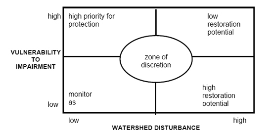
Figure 1. Conceptual framework for prioritizing watersheds for protection and restoration, according to their location in two-dimensional space defined by axes of disturbance and vulnerability to impairment.